The Laya Gasa TREK

The Laya-Gasa Trek is considered one of the most scenic treks in Bhutan, offering amazing views of some of the most pristine and unspoiled landscapes in Bhutan. This fourteen day, 217 km journey begins at Drukgyel in Paro and takes you through gorgeous alpine meadows, high mountain passes and dense sub-tropical jungles before terminating in Damji in Tashithang.

The first five days of this trek follow the same route as the Jomolhari Trek I through Jigme Singye National Park and offer awe-inspiring views of Mt. Jomolhari, Jichu Drake and Tsherimgang. On the sixth day the path diverges and you will depart Lingshi for the camp site at Chebisa, a charming little village adorned with a beautiful waterfall of crystal clear water.

Along the trail you’ll be able to spot indigenous animals such as blue sheep and Takins, the national animal of Bhutan. You’ll travel through remote mountain villages inhabited by Layaps (people of Laya), a distinct segment of the Bhutanese society with unique culture, traditions and appearance. Thhe trek also offers a day of relaxation at the famous Gasa hot springs that is sure to rejuvenate you.


This is one of the more difficult treks offered in Bhutan due to the high altitudes and steep ascents and descents along the path. The best seasons to complete this challenge are in April-June and Mid-September-Mid-November.


Season: Best from April to June and September to November
Max Altitude: 5,000 m/ 16,400 ft
Trek Duration: 12 nights/13 days

Day 1: To Thongo Zamba (start of trek)

Distance: 14km/8.7miles;
Total altitude gain: 390m/1,279ft;
Duration: 5-6 hours;
Campsite elevation: 3,200m/10,500ft;
Level of difficulty: Moderate

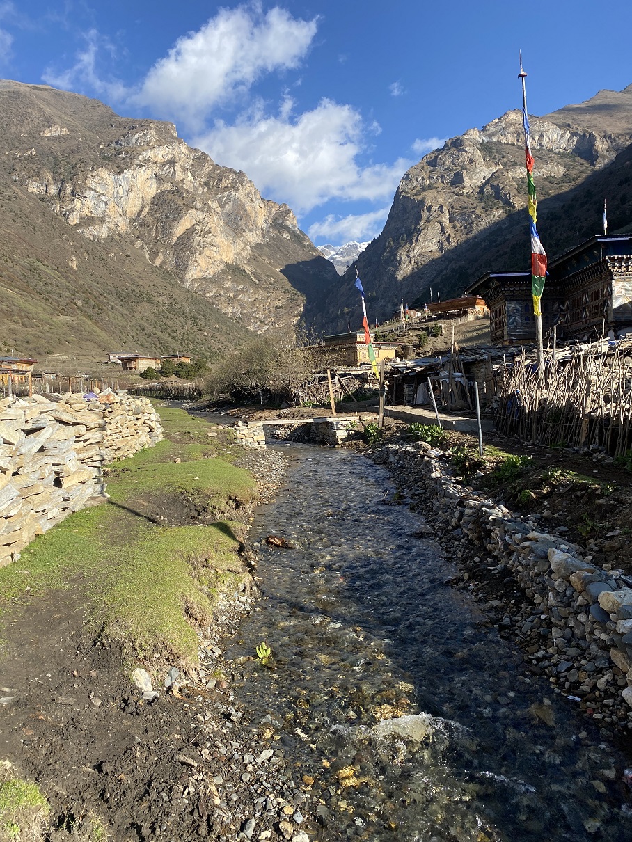
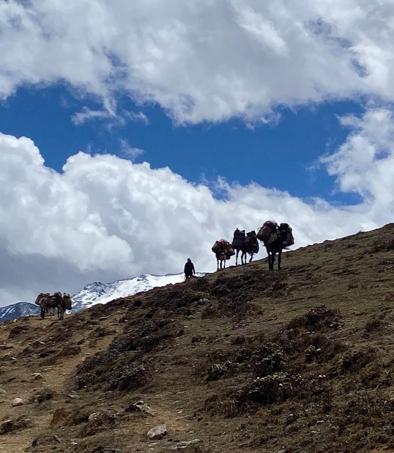
Past the ruined Drugyel Dzong, we drive further on a 18 km dirt road until we reach the road-head at an army post of Gunitsawa (2,810m/9,200ft), Beginning the Chomolhari trek, we walk for 5-6 hours to our first campsite at Thongo Zamba (3,200m/10,500ft). We are now trekking within Jigme Dorje National Park, the largest protected area in the country (4,350 sq kms.) which extends beyond Laya to Lunana in the east and all the territory to the south. Whilst it is a protected wilderness, the park management which is based at Gasa, has to cope with the needs of lowland farmers and semi-nomadic yak herders. There is an amazing variety of species of plants and animals in the park at both high and low altitudes. The forests are tall and thick, comprising a variety of oaks, maple, birch, larch pine and alders that will be replaced by more and more rhododendron and pines as we trek higher. There are numerous different varieties of the former, and depending on the onset of warmer temperatures after winter, flowers will be in bloom, or past bloom, as the lower altitudes flower earliest. As we climb higher the rhododendron species change from the common rhododendron arboreum (Nepal's national flower) to griffithianum and cinnabarinum. Our camp site is close by the river.

Camping…B, L, D

Day 2: Thongo Zamba to Soi Thangthangkha

Distance: 9km/5.6miles;
Total altitude gain: 410m/1,345ft;
Duration: 5-6 hours;
Campsite elevation: 3,610m/11,800ft;
Level of difficulty: Long moderate day but not difficult, muddy & bumpy path


This is the longest trekking day taking up to eight hours to reach the campsite. The trail again follows the Pa Chu (Paro river), ascending and descending through pine, oak and spruce forest. After crossing a bridge to the left bank of the river, we stop for a lunch. Then we continue along the river, climbing upwards through rhododendron, birch, fir and maple forest, and crossing the river once more before reaching our campsite (3,610m/11,800ft).

Camping…B, L, D

Day 3: Soi Thangthangkha to Jangothang

Distance: 14km/8.7miles;
Total altitude gain: 420m/1,380ft;
Duration: 4-5 hours;
Campsite elevation: 4,080m/13,385ft; Level of difficulty: Short & easy


The third day’s trek is relatively shorter one so it is possible to set off a little later and progress at a leisurely pace. The path ascends for a while until we reach the army camp. We then follow the river above the tree line, enjoying stunning views of the surrounding peaks. Hot lunch is served at a yak herder's camp. A short walk from here into the valley takes us to our campsite at Jangothang (4,080 m/13,385ft) where the view of Jhomolhari and Jichu Drake are spectacular. The area is rich in bird life. Birds sighted en route include the fire-tailed sunbird, Ibis bill, White-throated Dipper, Yellow-billed Chough, Rosy Pipit, Snow Pigeon, Blue-fronted Redstart, Plumbeous Water Redstart, Blood Pheasant, Snow Partridge and many more.

Camping…B, L, D

Day 4: Jangothang Halt (Rest day)

At Jangothang. A reserve day for acclimatisation. A side trip up the small valley towards Chomolhari takes us to a dramatic viewpoint and onto the glacier beneath. Alternatively we may make a scenic excursion up to Sopu lake set adjacent to Nye La pass, both will be worthy photo excursions. As far as mountaineering is concerned, these two peaks, like the rest of Bhutan, have seen little expedition activity from outsiders. Doug Scott successfully climbed Jichu Drake in 1988 on his third attempt, demonstrating that conditions are not so easy on this far east location of the Himalaya being first in line geographically for monsoonal influences.

Camping…B, L, D

Day 5: Jangothang to Lingzhi

Distance: 18km/11miles;
Total altitude loss: 85m/278ft;
Duration: 6-7 hours;
Campsite elevation: 4,010m/13,100 ft;
Level of difficulty: Strenuous


Depending on the conditions, yaks will replace ponies on this section of the trek to Lingzhi. The trail follows the stream for half an hour and crosses the bridge to the right bank. We now start our climb up the first ridge, enjoying breathtaking views of Jhomolhari, Jichu Drake and Tsheringang (6,789m/22,300ft). The trail then takes us across a fairly level valley floor until the climb up to Nyele-la pass (4,890m/16,000ft). We descend gradually from the pass to our campsite at Lingzhi (4,010m/13,100ft) enjoying a panoramic view of the mountain peaks and Lingzhi Dzong as we walk.

Camping…B, L, D

Day 6: Lingzhi to Chebisa

Distance: 10km/6.2miles:
Total altitude loss: 130m/426ft:
Duration: 5-6 hours;
Campsite elevation: 3,880m/12,729ft;
Level of difficulty: Moderate and pleasant


Today is the shortest walking day, and you can really take it easy. Shortly after starting you will reach a chorten below Lingshi Dzong. Here, you have the choice of staying on the main trail or taking a diversion up to the Lingshi Dzong (4,220m), which sits right atop a ridge. Besides a very special atmosphere of mystic silence Lingshi Dzong provides a great view over the valley. After Lingshi Dzong you will be passing the villages of Lingshi and Goyul. In Goyul, the stone houses are clustered together to a small compact village that is unusual in Bhutan where village houses are normally scattered. On reaching the campsite at Chebisa with a beautiful waterfall behind the village, you will have plenty of time to visit the village houses if you feel up to it.

Camping…B, L, D

Day 7: Chebisa to Shomuthang

Distance: 17km/10.5miles; Total altitude gain: 350m/1,148ft; Duration: 6-7 hours; Campsite elevation: 4,220m/13,845ft; Level of difficulty: Moderate hard

You walk through a wide pastureland towards Gobu La (pass). On the way, you will see a few people herding yaks. There is also a great chance to spot large herds of blue sheep above the trail. After crossing the Gobu La (4,410m/14,468ft), you descend to the valley, then climb again a little bit, and descend again to Shakshepasa (3,980m/13,057ft) where a helipad has been established. Climbing from here you will finally reach the campsite at Shomuthang, above a river, which is a tributary of the Nochu river.

Camping…B, L, D 

Day 8: Shomuthang to Robluthang

Distance: 18km/11miles; Total altitude loss: 60m/196ft; Duration: 6-7 hours; Campsite elevation: 4,160m/13,648ft; Level of difficulty: Moderate hard

As the walk is a little strenuous, it is advisable to start early. Climbing up the valley to view Kang Bum (6,526m/21,410ft) and some edelweiss. After two hours of climbing you will reach Jhari La (4,750m/15,584ft), from where you catch the first sight of Sinche La, the pass you will have to cross the day after. The big snow peak in the north is Gangchhenta (6,840m/22,440ft), better known as the Great Tiger Mountain. If weather is clear, Tserim Kang and the top of Jumolhari will be visible. The camp by the river is called Tsheri Jathang. Herds of takin, the Bhutanese National Animal, migrate to this valley in summer and remain for about four months. The valley has been declared a takin sanctuary. Climb up a little bit and you will reach the campsite at Robluthang in a rocky meadow.

Camping…B, L, D

Day 9: Robluthang to Limithang

Distance: 19km/11.8miles; Total altitude loss: 20m/65.6ft; Duration: 6-7 hours; Campsite elevation: 4,140m/13,582ft; Level of difficulty: Streneuous

After crossing Sinche La (5,005m/16,420ft) - the last and highest pass on the trek in case you don’t intend to continue the Snowman trek from Laya onwards - you descend to a little stone house where a few Laya women - dressed in typical Laya costume with long pointed bamboo hats on their head - live and offer their weaving products. Right behind the stone house you will see an impressive terminal moraine and a glacial lake at the foot of the valley. You can see classic examples of the lateral moraines where the glacier has pushed rocks up both sides of the valley. Below the moraine, you cross the Kango Chhu and soon reach the Limithang campsite. The peak of Gangchhenta towers over the campsite even though it’s quite a distance away.

Camping…B, L, D

Day 10: Limithang to Laya

Distance: 10km/6.2miles; Total altitude loss: 300m/984ft; Duration: 4-5 hours; Campsite elevation: 3,840m/12,598ft; Level of difficulty: Moderate

We walk along the river, one of the tributaries of the Mochu and through a forest of rhododendron and silver fir and then enter the village of Laya. The people of Laya are famous for their vertical stripe yak hair clothing and their strange conical bamboo hats. The women wear their hair long and much turquoise and jade jewelry. The features of the people are more Tibetan/Mongolian than the Bhutanese who live in the central valleys The rest of the day is spent at leisure or visiting village houses and mixing with the villagers. There are good views of the Masagang and the other peaks. In the village centre is a community school and a basic health unit with telephone connection. The campsite is below the school.

Camping…B, L, D

Day 11: Laya Halt

Rest day. Explore Laya village. You may visit any of the houses around as, by tradition, one can go to any house without an invitation. A cup of tea or Chang (local drink) is always offered.

Camping…B, L, D 

Day 12: Laya to Koina

Distance: 19km/11.8miles; Total altitude loss: 790m/2,591.8ft; Duration: 4-5 hours; Campsite elevation: 3,840m/12,598ft; Level of difficulty: Moderate hard

The trail winds up and down along the river valley of Mo Chhu affording breath-taking views of the crashing river, feeder streams and waterfalls. Lots of ups and downs will lead you to Kohi Lapcha (3,300m/10,826ft). The trek then drops down to the large stream of Koina Chhu, where you will find the campsite of Koina.

Camping…B, L, D

Day 13: Koina to Gasa/Tshachu

Distance: 14km/8.69miles;
Total altitude loss: 1,600m/5,249ft;
Duration: 6-7 hours;
Campsite elevation: 2,240m/7,349ft;
Level of difficulty: Strenuous


Today you will have your last climb of the Laya Gasa Trek. You will cross the Bale La (3,950m/12,959ft), after which the trail is all the way down till you reach Gasa village (2,770m/9,087ft), where you will find the first restaurants since starting from Drukgyel Dzong. There also is a campsite close to Gasa Dzong. You will descend for another one hour to the Gasa Tsachu (hot springs) and relax in the thermal water. The Gasa Tsachu (2,240m/7,349ft) is one of the most popular hot springs in Bhutan.

Camping…B, L, D

Day 14: Gasa/Tshachu to Punakha

Distance: 34km/21miles;
Duration: 3-4 hours

Transfer to Punakha (1,350 meters/ 4,430 feet). After the climb away from Gasa Tsachu to the road drive down the dirt road which winds through rolling hillsides with the vista of fields, villages and forests of oak and pine. Gasa Dzong will be visible behind you, glued to the valley wall, seeming afloat in space. The road follows Moch River through a lush semi-tropical gorge filled with banana trees, creepers and the sight of an occasional monkey. You will reach Punakha for lunch

connecting people,
nature,
and spirit

Contact Us

P.O.Box: 245
Changangkha, Thimphu
BHUTAN

Changangkha

Cell: 646.875.7772 (US), +975 7720 7220 (Bhutan)

WhatsApp: +975-77290123

We are open for booking.
Book your tour.

NOTICE

© Copyright 2023 - Bridge To Bhutan - All Rights Reserved